
The Father of Urban Planning: How Ildefons Cerdà Invented the Science of Cities and Why Barcelona Still Proves His Theories
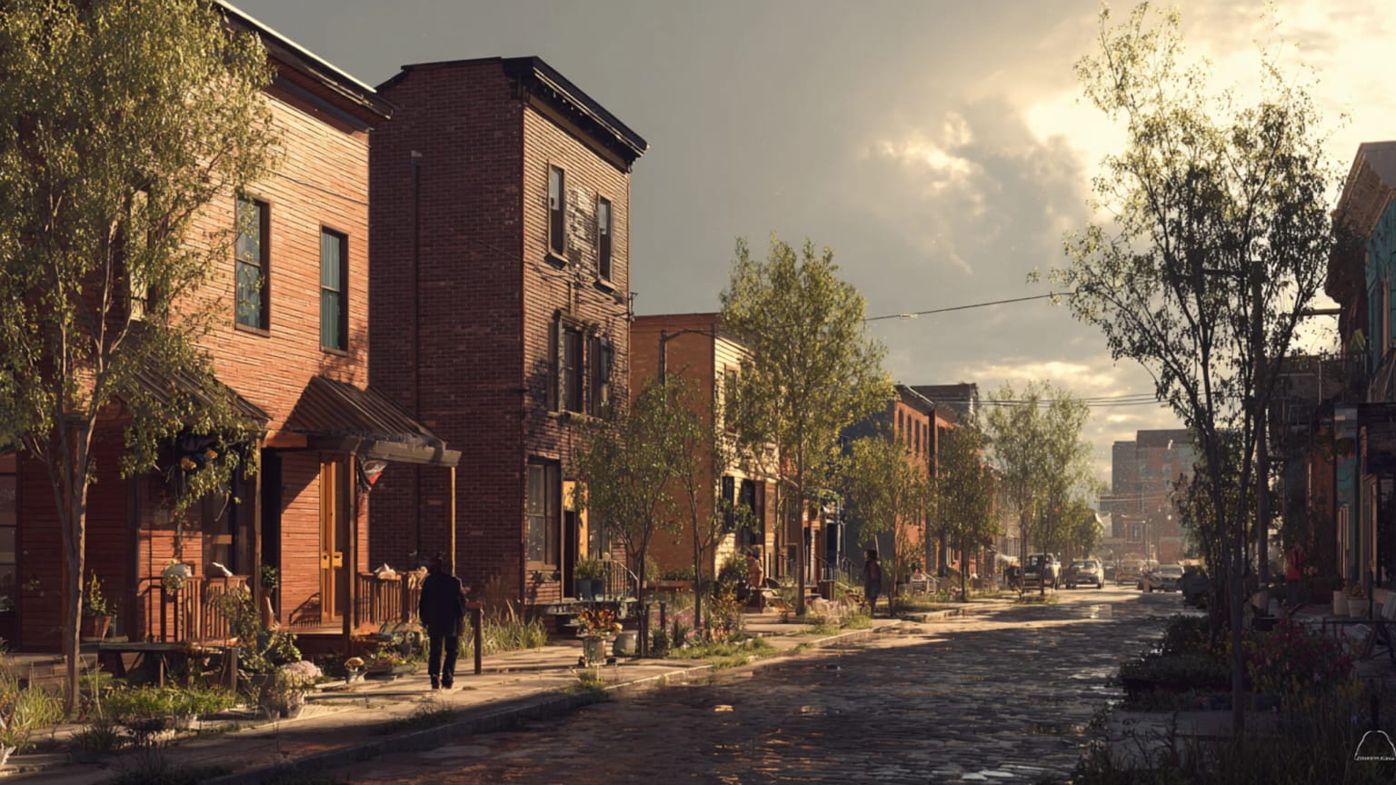
Walk through Barcelona's Eixample and you're moving through the world's first scientifically planned urban expansion. Every chamfered corner, every 113.3-meter block, every diagonal avenue was calculated to solve the particular problems of 19th-century urban life. What Ildefons Cerdà couldn't predict was how prescient his solutions would prove for 21st-century cities.

Key Insights
Essential takeaways from this chronicle
Ildefons Cerdà (1815-1876) literally invented urban planning as a scientific discipline, coining the term "urbanización" and establishing systematic approaches to city design still used today.
Point 1 of 5The Eixample's 113.3-meter blocks with chamfered corners were precisely calculated for sunlight, ventilation, and traffic flow—a radical departure from medieval city-building.
Point 2 of 5Cerdà's original vision included social housing, mixed-income blocks, and extensive green space, but economic pressures led to denser, more exclusive development than he intended.
Point 3 of 5Modern Barcelona's superblocks validate Cerdà's theories: reducing car traffic in his grid has measurably improved air quality and public health outcomes.
Point 4 of 5Contemporary urban challenges—climate adaptation, mobility, social equity—were anticipated in Cerdà's comprehensive planning methodology, making his approach more relevant than ever.
Point 5 of 5
That someone was Ildefons Cerdà i Sunyer, a 44-year-old Catalan engineer who would accidentally invent urban planning as a modern discipline while trying to solve Barcelona's particular crisis of growth. His story is also the story of how cities learned to think scientifically about themselves—and why, more than 160 years later, Barcelona's contemporary experiments with superblocks and climate adaptation keep proving his theories right.
⸻
The engineer who studied cholera
Barcelona in 1850 was suffocating. Literally. The city had been confined within medieval walls for centuries, its population compressed into one of Europe's densest urban cores. Inside those walls, mortality rates soared: 30.8 per thousand annually, compared to 24.5 in London or 22.5 in Paris. Cholera outbreaks swept through overcrowded tenements. Industrial smoke mixed with poor sanitation and nonexistent ventilation to create what contemporary observers described as a "pestilent atmosphere."
Cerdà, trained as a civil engineer at Madrid's prestigious Escuela de Ingenieros, had returned to Barcelona in 1848 with a technical mind and a growing political consciousness. When cholera struck again in 1854, he did something unprecedented: he conducted a systematic study of the relationship between urban form and public health. Walking street by street, mapping mortality rates against building density, documenting the width of alleys and the height of buildings, he created what may be the first quantitative analysis of city planning's life-and-death consequences.
His findings were stark. The densest areas of the old city—some reaching 859 inhabitants per hectare—suffered mortality rates nearly double those of less crowded districts. Buildings rose to six stories or more along alleys barely three meters wide, creating dark canyons where tuberculosis festered and infant mortality peaked. Barcelona, Cerdà concluded, wasn't just unhealthy—it was anti-urban, a contradiction of the very promises cities were supposed to fulfill.
The solution, he believed, required inventing an entirely new science.
⸻
The grid as social technology
When the Spanish government finally authorized Barcelona's expansion in 1859, Cerdà was ready with a plan so comprehensive it made contemporary urban extensions look like sketches. Where other planners drew streets and sold lots, Cerdà had calculated sunlight angles, wind patterns, population densities, and traffic flows for a grid that would house 360,000 residents across 1,000 hectares.
The mathematical precision was revolutionary. Each block measured exactly 113.3 meters on a side—large enough to accommodate courtyards for light and ventilation, small enough to maintain walkable connectivity. The chamfered corners, cutting the blocks into distinctive octagons, weren't decorative but functional: they widened intersections for better visibility, improved air circulation, and created small plazas at every crossing.
Streets were stratified by function: 20-meter residential streets, 30-meter commercial avenues, and 60-meter grand boulevards (though only one of his planned diagonals would ultimately be built). Building heights were capped at 16 meters—roughly four stories—to ensure every apartment received direct sunlight. Most radically, blocks were designed to be built on only two sides, leaving the interior as communal gardens.
This wasn't just urban design; it was social engineering with survey-grade precision. Cerdà envisioned mixed-income blocks where workers and bourgeoisie would live in the same buildings, differing only in floor level. He calculated that proper ventilation and sanitation could reduce disease transmission by 60%. He planned schools, markets, and hospitals at regular intervals, creating a city where essential services would always be within walking distance.
"Urbanización," the word he coined, meant more than city-building—it meant the scientific application of technology and social theory to create environments where humans could flourish.
⸻
Theory meets capital (and capital wins)
The gap between Cerdà's vision and what actually got built tells the familiar story of planning ideals colliding with economic reality. Almost immediately, developers began violating his regulations. Blocks that were meant to be built on two sides sprouted buildings on all four. Courtyards designed as communal gardens became private patios. Heights exceeded his carefully calculated limits.
The result was denser and more exclusive than Cerdà had envisioned, but still radically better than the medieval city it replaced. The Eixample attracted Barcelona's growing middle class, who filled its regular blocks with an explosion of Modernista architecture—the Art Nouveau-influenced buildings by Antoni Gaudí, Lluís Domènech i Montaner, and Josep Puig i Cadafalch that would eventually make the district a UNESCO World Heritage site.
By 1900, the Eixample housed over 200,000 residents in what was arguably Europe's most systematically planned urban district. Mortality rates had dropped dramatically. The grid's regular geometry made it easy to extend water, gas, and eventually electrical networks. The chamfered intersections proved ideal for the horse-drawn omnibuses that provided the city's first public transport.
Yet Cerdà never saw his full vision realized. He spent his family fortune on planning studies and proposals for Barcelona and other Spanish cities, pioneering regional planning concepts that wouldn't be widely adopted for another century. He died in 1876, heavily in debt, having never been paid for the Eixample design that had transformed Barcelona into a modern city.
⸻
The grid that keeps proving itself
The true test of Cerdà's genius would come more than a century later, when Barcelona began experimenting with traffic restrictions within his grid. Starting in the 1990s, and accelerating with the introduction of "superblocks" in the 2010s, the city began reclaiming street space from cars and returning it to pedestrians, cyclists, and community use.
The results have been measurable vindications of Cerdà's theories. Studies by the Barcelona Institute for Global Health show that superblocks—clusters of nine city blocks where through traffic is restricted—have reduced nitrogen dioxide concentrations by 21% and particulate matter by 17%. Noise levels have dropped by 2-5 decibels. Green space per resident has increased, and surveys show improved mental health and social cohesion.
What makes these improvements possible is the underlying structure of Cerdà's grid. The 20-meter streets he designated for local traffic work perfectly as pedestrian-priority spaces. The regular geometry makes it easy to redirect vehicles to the 30-meter avenues. The chamfered corners provide small plazas for bike parking and community gathering without requiring major reconstruction.
Barcelona's contemporary climate strategy relies heavily on expanding tree cover and reducing urban heat islands—goals that align precisely with Cerdà's original emphasis on ventilation and green space. His plan for diagonal avenues connecting different parts of the city has inspired new cycling routes. The market locations he calculated for walkable access remain community anchors 160 years later.
Modern Barcelona hasn't simply inherited Cerdà's grid—it has actively chosen to fulfill his vision in ways his own era couldn't implement.
⸻
The discipline he founded
Cerdà's influence extends far beyond Barcelona. His insistence on systematic study, quantitative analysis, and comprehensive planning established urban planning as a professional discipline distinct from architecture, engineering, or public administration. His methodology—survey existing conditions, analyze relationships, design interventions, monitor outcomes—became the foundation of 20th-century planning practice.
The garden city movement in England, the City Beautiful movement in America, and the modernist planning theories of the Bauhaus all built on principles Cerdà had established: that cities could be scientifically designed for health, efficiency, and social equity. His integration of transportation, housing, and public services anticipated comprehensive planning approaches that wouldn't become standard practice until the mid-20th century.
Contemporary sustainable city initiatives—from Copenhagen's cycling networks to Singapore's integrated urban planning—follow analytical methods Cerdà pioneered. His emphasis on public health, social mixing, and environmental conditions resonates strongly with current debates about equity, climate adaptation, and urban resilience.
The Barcelona Protocol, a 21st-century framework for neighborhood-scale urban innovation, explicitly references Cerdà's methodology: systematic diagnosis, technical innovation, social participation, and measurable implementation. Cities from Paris to Medellín have studied Barcelona's superblock model, spreading Cerdà's grid logic to different urban contexts.
⸻
Lessons for the next century
What makes Cerdà's work enduringly relevant isn't just that he got many details right, but that he established a way of thinking about urban problems that remains productive. He approached cities as complex systems where form, function, and social outcomes were interconnected. He insisted that planning decisions should be based on evidence rather than tradition or aesthetics. He understood that cities were not static monuments but dynamic environments that needed to adapt to changing technologies and social needs.
These insights feel urgent as cities worldwide grapple with climate change, technological disruption, and growing inequality. Cerdà's emphasis on public health takes on new meaning as urban air quality, heat stress, and pandemic transmission become global concerns. His integration of transportation and land use provides a template for reducing car dependency. His vision of mixed-income neighborhoods offers alternatives to the spatial segregation that characterizes many contemporary cities.
The Eixample's success also illustrates the importance of infrastructure that can evolve. Cerdà's grid was designed for horse-drawn vehicles but adapted easily to cars, buses, and bicycles. His block structure accommodated gas lighting, electric power, telecommunications, and fiber optic networks. The geometric regularity that seemed rigid proved remarkably flexible.
Perhaps most importantly, Cerdà demonstrated that urban planning could be both technically rigorous and socially ambitious. His work succeeded not despite its comprehensive scope but because of it. He understood that effective planning required addressing transportation, housing, health, and social equity as interconnected challenges rather than separate problems.
⸻
The view from above
Flying over Barcelona today, the Eixample still looks like graph paper made flesh. But from ground level, walking through neighborhoods where children bike to school on protected lanes through streets that once carried heavy traffic, where elderly residents gather in small plazas created by chamfered corners, where buildings designed 150 years ago house contemporary artists and tech workers and immigrant families, the grid reveals itself as something more dynamic than geometric order.
It's a living experiment in how cities can be both planned and adaptive, both systematic and humane. The man who died in debt and obscurity in 1876 had created not just a district but a methodology—a way of thinking about urban problems that continues to generate solutions for challenges he could never have anticipated.
In that sense, every superblock is a monument to Ildefons Cerdà, every protected bike lane a vindication of his theories, every measurement of reduced air pollution a confirmation of his central insight: that cities can be scientifically designed to support human flourishing, and that the work of urban planning is never finished—only continuously adapted to serve the next generation of residents who call these calculated spaces home.
⸻
References & Further Reading
- Aibar, E. & Bijker, W. (1997). Constructing a City: The Cerdà Plan for the Extension of Barcelona. Science, Technology and Human Values 22(1), 3-30.
- Busquets, J. (2005). Barcelona: The Urban Evolution of a Compact City. Harvard University Graduate School of Design.
- Cerdà, I. (1867). Teoría General de la Urbanización. Madrid: Imprenta Española.
- Mueller, N., Rojas-Rueda, D., Cole-Hunter, T., et al. (2017). Health Impact Assessment of Active Transportation: A Systematic Review. Preventive Medicine 76, 103-114.
- Mueller, N., Rojas-Rueda, D., Basagaña, X., et al. (2020). Health Impact Assessment of Cycling Network Expansions in European Cities. Preventive Medicine 109, 145-154.
- Permanyer, L. (2008). Cerdà and His Barcelona: The Need for Urban Planning. Barcelona: Edicions Polígrafa.
- Rosselló, V. M. (1999). Ildefonso Cerdà (1815-1876). Boletín de la Asociación de Geógrafos Españoles 28, 125-156.
- Sabaté, J. (2010). From the Cerdà Plan to the Barcelona of Today. Town Planning Review 81(3), 253-282.
- Tatjer, M. (2008). Cerdà, Urbanización and the Barcelona Eixample. Planning Perspectives 23(4), 499-510.
- UNESCO World Heritage Centre (2005). Works of Antoni Gaudí. World Heritage List documentation.
This essay is part of Atlas Urbium's ongoing series examining the pioneers of modern urban planning and their contemporary relevance.
Continue Reading
Why New Apartments Feel Smaller Than Their Plans
New flats are warmer, safer and more efficient than old ones — and often feel worse to live in. Windows, ceilings and corridors reveal the loss of spatial generosity after Art Nouveau and Art Deco, and why compliant housing can still be uncivilized.

The Right Height: How Mid-Rise Cities Beat Both Sprawl and Towers
Five to eight storeys is the sweet spot for sustainable cities. Here's how Vienna, Vancouver, and Melbourne can build walkable, affordable, climate-conscious neighbourhoods without choosing between sprawl and glass towers.
When the Minimum Standard Becomes the Home
Light, ceiling height, corridors, floor area — and the quiet dismantling of residential quality. When regulation becomes the ceiling instead of the floor, cities produce dwellings designed for minimum life.