The Los Angeles That Almost Learned to Walk
Parks, rivers, streetcars — and the strangled city plan of 1930. Los Angeles is often treated as if its car-dependence were destiny. It wasn't. It was a decision, made and remade for a century.

Key Insights
Essential takeaways from this chronicle
In 1930, the Olmsted Brothers and Harland Bartholomew & Associates submitted "Parks, Playgrounds and Beaches for the Los Angeles Region," a regional plan for roughly 200,000 acres of connected parks, river corridors, and parkways. The committee that commissioned it never adopted it.
Point 1 of 5The Pacific Electric Railway's "Red Cars" formed the world's largest electric interurban rail system in the 1920s, with more than 1,000 miles of track linking Los Angeles to Pasadena, Long Beach, Santa Monica, San Bernardino, and dozens of other destinations.
Point 2 of 5The Army Corps of Engineers began channelizing the Los Angeles River in 1936 after a series of deadly floods; the catastrophic 1938 flood hardened the political case for a fully concrete, single-purpose flood channel rather than a multi-functional parkway corridor.
Point 3 of 5Today, 13% of Los Angeles land is used for parks and recreation, below the national median of 15%. Low-income neighborhoods have 65% less park space per person than the city average, and 85% less than high-income neighborhoods.
Point 4 of 5One city estimate puts the cost of bringing Los Angeles up to peer median park-service levels — including deferred maintenance and new parks — at roughly 15 billion dollars, illustrating how much more expensive land and infrastructure become once early acquisition is skipped.
Point 5 of 5
Los Angeles did not have to become this Los Angeles.
In the late 1920s, the region stood at a fork in the civic road. It already had two ingredients that could have produced a radically different metropolis: a vast electric rail network and a visionary regional parks plan. One system moved people across the basin without cars. The other imagined mountains, rivers, beaches, schoolyards, playgrounds, and parkways as a connected public landscape. Together they pointed toward a city that might have been polycentric, green, tram-oriented, walkable by neighborhood, and stitched together by river corridors rather than divided by freeways.
The failure was not that Los Angeles lacked imagination. The failure is that it had imagination, commissioned it, printed it in limited form, and then put it in a drawer.
The plan usually misremembered as a "1927 report" was commissioned in 1927 and submitted in 1930 as Parks, Playgrounds and Beaches for the Los Angeles Region, prepared by the Olmsted Brothers and Harland Bartholomew & Associates for the Citizens Committee on Parks, Playgrounds and Beaches. It proposed an integrated regional system of parks, playgrounds, beaches, scenic parkways, river corridors, and protected open space — almost 200,000 acres by one summary — but the committee that had commissioned it never adopted it.
That is the hinge. Los Angeles saw the future, and then looked away.
The plan that understood Los Angeles before Los Angeles did
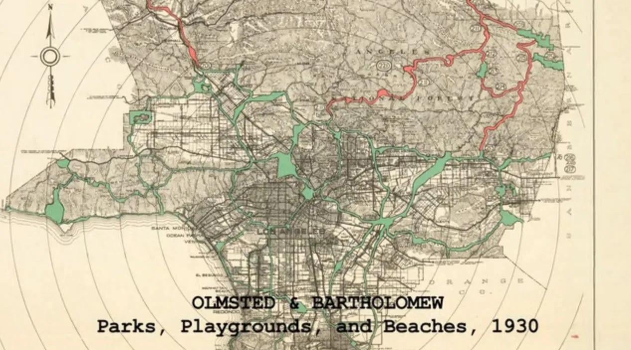 The Olmsted-Bartholomew plan, submitted in 1930: a connected regional system of parks and green parkways (shown in green) that the committee that commissioned it never adopted.
The Olmsted-Bartholomew plan was not a decorative parks proposal. It was a regional urban theory. It understood that Los Angeles would not become a compact East Coast city with one grand central park and a neat ring of neighborhoods around it. The region was already spreading thinly across a basin of mountains, washes, valleys, beaches, oil fields, agricultural land, rail corridors, speculative subdivisions, and dry riverbeds. A single park would not fix a city like this. Los Angeles needed a network.
The report proposed a distributed system: local playgrounds, larger parks, beaches, mountain and canyon reservations, river corridors, and parkways connecting them across the region. Later summaries describe the plan as a system of parks connected by "pleasureways," with roughly 200,000 acres of green space. A recent historical account gives a more granular picture: about 71,000 acres of smaller neighborhood parks and 92,000 acres of larger parks and reserves, connected by approximately 440 miles of green parkways. It also notes that the plan sought to put residents within about a half-mile — roughly a ten-minute walk — of a park, a standard now widely used in park-access planning.
This was not merely decorative. It was infrastructural. The parkways were not just scenic drives for Sunday outings. They were corridors of access, flood management, public health, recreation, and regional identity. The Los Angeles and San Gabriel Rivers were not imagined as concrete disposal chutes for stormwater; they were potential connective tissue.
That is why the plan still feels current. It anticipated several ideas cities now treat as advanced: green infrastructure, schoolyards as shared neighborhood parks, public beach access, river restoration, ten-minute park access, regional ecological networks, and public open space as a health system. The LA River Master Plan explicitly recognizes that the Olmsted-Bartholomew plan foresaw rapid urbanization and understood the river's potential to connect communities across the 51-mile corridor.
The report's diagnosis was simple: if Los Angeles did not acquire open space early, development would fill it. Land would get expensive. Public opportunity would disappear. This is exactly what happened.
Why it was shelved
The plan was commissioned by civic and business interests, including the Los Angeles Chamber of Commerce, at a moment when the region worried that it lacked adequate parks for its fast-growing population. But once the plan arrived, its own ambition became politically inconvenient. It required money, regional coordination, land acquisition, and a new kind of public authority with enough power to think beyond municipal fragments. The LA River Master Plan summarizes part of the implementation problem: the Olmsted-Bartholomew plan was expensive and difficult to assign to any existing governing body; it would have required a new governance structure.
There was also a sharper political economy. The plan threatened land speculation.
A park plan of that scale does not merely add amenities. It removes land from future private exploitation. It says: this river edge, this canyon, this beach, this schoolyard, this corridor, this floodplain — these belong to the civic future, not to the next subdivision map. That is a direct challenge to a growth machine. Historical accounts describe the report dropping from sight after a small burst of public attention; historians Greg Hise and William Deverell later argued that the Chamber limited its circulation, and the plan's threat to land speculation is central to accounts of its rejection.
In other words, Los Angeles did not merely fail to plan. It planned — and then chose not to govern.
That difference matters. The city's later sprawl was not a natural law. It was the accumulation of decisions: to prioritize private subdivision over regional open space, road capacity over rail maintenance, flood control through concrete rather than multi-functional river corridors, and real-estate flexibility over a public landscape system.
The streetcar city that already existed
The parks plan was not floating in isolation. It arrived in a region that already had an enormous electric rail network.
The Pacific Electric Railway — the Red Cars — was America's largest interurban electric railway system, with more than 1,000 miles of rail lines across Southern California. USC Libraries describes the Pacific Electric as the world's largest electric railway system during the 1920s. At its peak, the network connected Los Angeles to Pasadena, Long Beach, Santa Monica, San Pedro, Redondo, Pomona, Riverside, San Bernardino, Newport Beach, and many other destinations. It was not a modern metro, and it had problems: uneven speeds, street-running congestion, private ownership, real-estate motives, and later underinvestment. But it gave Los Angeles a regional rail skeleton.
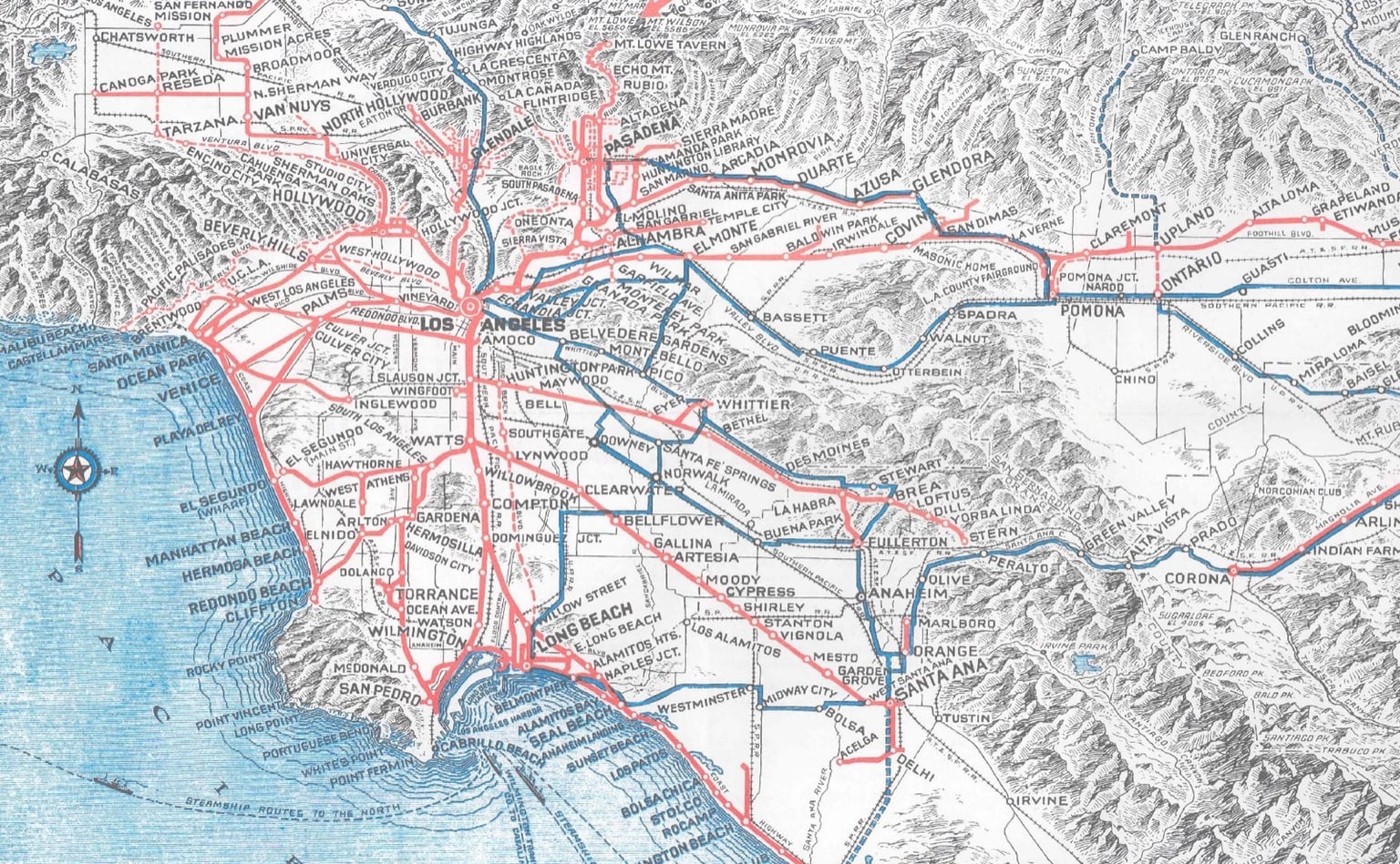 The Pacific Electric route map: more than 1,000 miles of electric rail already reaching Pasadena, Santa Ana, San Bernardino, and the coast.
The Los Angeles Railway Yellow Cars handled many local streetcar trips within the denser central city, while the Red Cars connected the wider region. The system helped produce streetcar suburbs — places built around rail access before the automobile fully took over the basin.
This is the other forgotten Los Angeles: not a Manhattan of the West, but a rail-linked garden metropolis. Low to medium density, yes. Polycentric, yes. But not necessarily car-dependent. With different governance, rail could have been upgraded rather than abandoned; rights-of-way could have become light-rail, tram, busway, and cycle corridors; station areas could have densified around local centers; the parkways could have tied rivers, schools, and neighborhoods into a walkable ecological network.
Los Angeles once had the bones of such a city.
Then came the long surrender to the automobile. The decline of the streetcars was not a single villain's doing. It involved private automobile adoption, freeways, deteriorating rail infrastructure, regulated fares, changing land use, weak public support, and motorization interests. PBS's Lost LA describes the region's arc from streetcar suburbs to auto-oriented life and now back toward rail-oriented reinvestment. Passenger service on the Pacific Electric dwindled through the 1950s; the last interurban line to Long Beach ended in 1961, and modern light rail later reused part of that corridor when the Blue Line opened in 1990.
The result was not merely a change in transport mode. It was a change in urban psychology. The city stopped thinking of streets and corridors as shared civic systems and increasingly treated them as conduits for private vehicles. The park plan died. The rail network decayed. The freeways arrived.
The river that became a drain
The most powerful symbol of the missed Los Angeles is the river.
The Los Angeles River could have been a regional green corridor: floodplain, parkway, habitat, cycling route, walking route, public space, cooling system, and social connector. The Olmsted-Bartholomew plan saw this possibility. The LA River Master Plan explicitly notes that the 1930 plan recognized the river's capacity to unite communities rather than divide them.
Then the floods came.
Southern California floods in the 1930s were severe and deadly. The U.S. Army Corps of Engineers says it began channelization of the Los Angeles River in 1936 after a series of floods caused millions of dollars in damage and hundreds of deaths. The catastrophic 1938 flood hardened the region's political demand for flood control; it is often described as the final blow that pushed the river toward concrete channelization.
The concrete channel worked in one narrow sense: it moved floodwaters quickly to the sea and reduced flood risk for a rapidly urbanizing basin. Flood control was not unnecessary — Los Angeles sits below steep mountains that can deliver violent flows after storms. But the choice was not simply between deadly floodplain chaos and total concrete removal of the river's civic function. The failure is that Los Angeles never seriously built the multi-functional river system the earlier regional park logic implied. The river became an engineered absence: visible but unusable, present but socially inert, a corridor that divided instead of connected.
Modern LA River revitalization efforts are, in part, an attempt to repair that design choice. But retrofitting a river after a century of concrete, roads, rail yards, industrial land, and fragmented jurisdictions is harder than protecting the corridor before it was built over. The original plan understood the timing problem. Land is cheap before it is developed. Rivers are easier to save before they are entombed.
The city that could have existed
So what might Los Angeles have become with a different set of decisions?
Not Amsterdam with palm trees. Not a compact European city set beside the Pacific. The geography and political economy were different. Los Angeles was always going to be decentralized, multi-nodal, sunny, and horizontal. Its mountains, basins, beaches, and oil-age boom made a particular form likely.
But it could have become a green tram metropolis.
Imagine a Los Angeles where the Red and Yellow Car systems were publicly rationalized, upgraded, and protected as the backbone of regional mobility — evolved with grade separation where needed, dedicated lanes where possible, signal priority, station-area density, fare integration, later light-rail conversion, and local feeder buses. The rights-of-way existed. The corridors existed. The habit of rail travel existed.
Now overlay the Olmsted-Bartholomew open-space system: river parkways along the Los Angeles and San Gabriel Rivers; schoolyards open as neighborhood play spaces; beaches acquired for broad public access; canyon and mountain reservations protected; local parks within walking distance of residents; greenways connecting districts; parkways functioning as recreational, ecological, and flood-management corridors at once.
This city would still have cars. Cars would not, however, have become the organizing principle of urban form. Neighborhoods around rail stops could have matured into walkable centers. Streetcar suburbs could have intensified gently rather than being stranded into car dependence. River corridors could have provided cycle and walking networks long before "active mobility" became planning shorthand for people getting around on foot.
The air would likely have been cleaner earlier. The urban heat island would be softer. Low-income neighborhoods might have had more park access if the plan's equity logic — playgrounds and local parks distributed across residential districts — had been carried out. Beach access would have been broader. The LA River might be a civic spine instead of a concrete trench. Children across South LA, East LA, and the San Fernando Valley might have grown up with park systems as ordinary daily infrastructure rather than scarce geography.
Would Los Angeles have avoided all sprawl? No. Would racial exclusion, redlining, oil politics, freeway displacement, and speculative land development have vanished? No. But the city would have had stronger public counterweights: land reserved for common use, rail corridors kept alive, and a physical grammar that made walking, cycling, and transit normal in more places.
Urban form does not solve politics on its own. But it shapes what politics has to work with. Los Angeles handed too much of that ground to private land and private vehicles.
The equity cost
Today's park geography carries the long shadow of that decision.
Trust for Public Land's ParkScore data show that 13% of Los Angeles land is used for parks and recreation, below the national median of 15%, and that low-income neighborhoods in Los Angeles have 65% less park space per person than the average LA neighborhood, and 85% less than high-income neighborhoods. The broader Los Angeles County Park Needs Assessment describes the countywide effort to quantify park need and guide investment across cities and unincorporated areas. Equity Atlas analysis finds that low-income, park-deficient areas disproportionately include Black and Latinx residents, and that children are overrepresented in these under-served areas.
This is where the 1930 plan becomes more than a lost aesthetic. It is lost public-health and equity infrastructure.
Parks are often discussed as amenities, as if they were incidental to urban life. They are not. They are shade, play, exercise, flood absorption, cooling, mental health, social mixing, clean air, childhood development, and civic equality. In a hot, unequal city, park access functions as a public health system. A park-poor neighborhood is not merely less pleasant. It is more exposed.
Had the Olmsted-Bartholomew plan been carried out early, much of the land now too expensive to acquire could have been reserved before speculation hardened around it. Recent reporting on Los Angeles park needs suggests the scale of the repair bill: one city estimate puts the cost of bringing Los Angeles up toward peer median service levels — including deferred maintenance and new parks and amenities — at roughly 15 billion dollars. Whatever the precision of any single estimate, the direction is clear: failing to acquire public land early becomes extraordinarily expensive later.
Walkability is not density alone
A greener Los Angeles would also have been a more walkable Los Angeles — but not simply because parks make walking pleasant. Walkability requires a network of destinations, shade, safe crossings, transit, short blocks or permeable routes, mixed uses, and a reason to walk.
The Olmsted-Bartholomew plan would have helped because it treated open space as distributed infrastructure, not isolated scenery. If every residential district had playgrounds, schoolyards, park links, and safe green corridors, walking would have had daily purpose. If streetcar corridors had been maintained and intensified, walking would have connected to regional movement. If rivers and washes had become parkways rather than fenced channels, they could have served as long-distance pedestrian and cycling routes.
This is the same relationship many successful cities exploit today. Barcelona's superblocks work not merely because they remove traffic from interior streets, but because the surrounding grid still connects people to transit, shops, schools, and public life. Paris's walkability works because dense mixed-use blocks, transit, and parks sit close together. Copenhagen's cycling works because streets, land use, transit, and public space reinforce each other.
Los Angeles had the ingredients for its own version. Not the same recipe — the city's distances are larger, its heat harsher, its polycentric form more pronounced. But a tram-and-parkway city could have made many daily trips local, shaded, and rail-linked, producing walkable districts connected by electric rail and green corridors rather than isolated car-dependent islands connected by freeways.
The core mistake was not low density alone. It was unstructured decentralization: growth without enough public-space reservation, transit protection, or land-use discipline around corridors. Sprawl is not just distance. It is distance without civic structure.
The freeway as anti-parkway
The word "parkway" itself contains the road not taken. In the Olmsted tradition, a parkway was not merely a traffic facility. It was a landscaped connector, a civic corridor, a way to move through the city without dividing it.
Los Angeles built another kind of corridor instead: the freeway.
Freeways solved some mobility problems, especially in the early years, but they imposed a different grammar: speed, separation, noise, pollution, land consumption, neighborhood division, and dependence on private vehicles. They did not simply carry traffic; they reorganized land value and social life around vehicular access, making some places reachable and others disposable.
A parkway-river-streetcar city would have used corridors differently. Some would carry rail. Some would carry stormwater and recreation. Some would carry bikes and walking paths. Some would carry cars, but not all would be given over to them entirely. The city would have had a richer hierarchy of movement.
Los Angeles is now trying to retrofit what it did not preserve. Metro rail expansion, LA River revitalization, open-streets events, park funding measures, schoolyard greening, bus lanes, active transportation plans, and park-equity initiatives are all fragments of a delayed correction. They are valuable. But they are harder now because the right-of-way has been claimed, the land subdivided, the habits formed, and the political coalitions hardened.
The modern opportunity
The Olmsted-Bartholomew plan cannot simply be built now. The land is gone or vastly more expensive. Jurisdictional fragmentation remains. Climate change adds heat, fire, and water volatility. Housing need is severe. Equity concerns are sharper. The old plan also carried the assumptions of its era and would need democratic updating.
But its logic remains useful.
A twenty-first-century version would rest on five principles.
First: treat rivers and washes as green infrastructure corridors. Flood control must remain real, but concrete-only thinking is outdated. Where feasible, widen, terrace, green, shade, reconnect, and make access equitable. The river should function as flood infrastructure and civic infrastructure at once.
Second: build park access through small land moves as well as large projects. Schoolyards, utility corridors, underused parcels, parking lots, freeway caps, stormwater basins, alleys, mini-parks, and joint-use agreements matter. The original plan understood that local play space was as important as grand landscapes.
Third: tie parks to transit. A park reachable only by car is still useful, but it serves a different civic function. Rail and bus corridors should connect residents to beaches, mountains, rivers, and neighborhood parks. The old Red Car geography and the current Metro system should be read together — as one long, unfinished map.
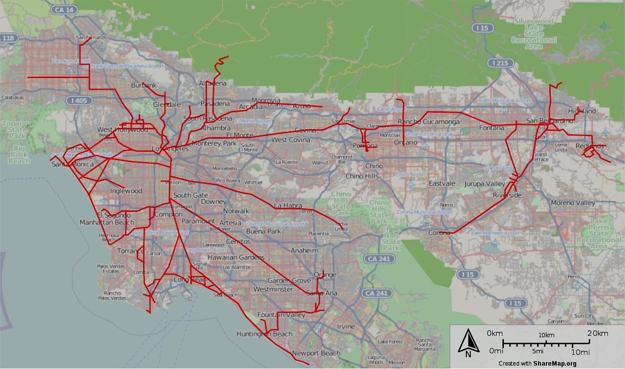 Today's Metro rail network traces only a fraction of the ground the Pacific Electric once covered.
Fourth: densify around rail and green corridors without displacing the people the improvements are meant to serve. This is the hardest part. Green investment can produce green gentrification. A revived river can become a real-estate asset that prices out the people it should serve, unless affordable housing, tenant protections, and community ownership are designed into the plan from the start.
Fifth: make cars optional rather than necessary for more trips. Los Angeles does not need to eliminate cars to improve. It needs frequent transit, shaded walking routes, protected cycleways, mixed-use zoning, and streets designed for pedestrians as well as vehicles.
This is not utopian. It is basic civic maintenance.
Why the counterfactual matters
Why dwell on an unbuilt plan from 1930? Because counterfactuals change what we understand to have been possible.
If Los Angeles had no alternative blueprint, today's city might look like an inevitability. But it had one. It had a plan for parks. It had a rail network. It had rivers that could have become corridors. It had public anxiety about park shortage before the land was lost. It had professionals who understood that rapid growth without open space would eventually strangle the region.
The failure, then, was not imagination. It was governance.
This pattern is not unique to Los Angeles, but Los Angeles is unusually instructive because the evidence is so visible. The city is a record of missed integrations: rail without lasting public stewardship, a river without civic life, beaches with unequal access, neighborhoods without enough parks, freeways where parkways might have stood, and now a substantial effort to rebuild in fragments what could once have been reserved as a system.
The lesson is direct: regional planning has to acquire land, protect corridors, and govern mobility before speculative urbanization closes the door. After that, every good idea becomes a retrofit.
The city still possible
Los Angeles will never become the city of the 1930 report. That city is gone, built over by subdivisions, freeways, parking lots, channel walls, and decades of car-centered decisions. But the report remains relevant because it offers a different civic imagination: not Los Angeles as private parcels connected by traffic, but Los Angeles as a regional landscape-city.
The current city still has real assets. Mountains. Beaches. The LA River and San Gabriel River corridors. Metro rights-of-way. Wide streets that can be reallocated. Schoolyards. Drainage basins. Underused commercial land. A climate that supports outdoor life much of the year, and a changing climate that makes shade and parks more urgent still. A population that already lives polycentrically. And historical proof that Los Angeles was never required to be only a car city.
The city's next planning effort does not need to imitate New York, Paris, or Copenhagen. It could become the Los Angeles it almost became: a polycentric tram-and-park metropolis, where density gathers around transit, rivers cool and connect neighborhoods, schoolyards double as parks, beaches are public, and walking is an ordinary way of reaching daily life rather than an exception.
That future would still be Los Angeles — sprawling, bright, multilingual, restless, full of contradictions. But it would be a version of the city that kept more of its own best plan.
The old report warned that without coordination and investment, regional growth would tend to strangle itself. Nearly a century later, that reads less like planning prose than prophecy. The question is whether Los Angeles is ready to stop proving it right.
Continue Reading
The View from Below: How London Mistook Skyscrapers for Density
London spent twenty years building upward in the name of the compact city. From the pavements of Shoreditch the arithmetic looks different: the tower privatises the panorama and socialises the silhouette.
Canals Under Pressure: Amsterdam and the Living City Review
Amsterdam ranks 10th in The Living City Review 2026 with an adjusted score of 76.5. It remains one of Europe’s finest cities for daily life, but housing scarcity and tourism pressure have turned beauty into a harder civic bargain.
The Living City Review 2026: A Human-Scale Ranking of the World's Great Cities
Not the best city, the happiest city, or the most powerful city — but the one where a full life is possible. The Living City Review scores 36 great cities on ten criteria of daily life, then subtracts the shadows: housing extraction, car-dependence, inequality, climate negligence.