When the Road Went Away: San Francisco, Seoul and the Myth of Fixed Traffic
Planners treat traffic as a fixed volume that must go somewhere. When roads have been widened, removed or narrowed, drivers have changed their routes, their timing, their mode and sometimes their minds.

Key Insights
Essential takeaways from this chronicle
The Embarcadero Freeway carried about 60,000 cars a day at its peak. The boulevard that replaced it carried about 26,000 in 2000, and the closure did not produce the gridlock that had been predicted.
Point 1 of 5Across US metropolitan areas, vehicle-kilometers traveled on interstate highways rise in proportion to lane-kilometers, and new lanes divert little traffic from other roads.
Point 2 of 5A review of more than 70 cases of road-space reallocation in 11 countries found that predictions of traffic problems were often unnecessarily alarmist and that overall traffic could fall significantly.
Point 3 of 5Seoul demolished an elevated highway and narrowed the road beneath it, on a corridor that carried about 170,000 vehicles a day, and opened 5.84 kilometers of restored stream in 2005. Bus ridership in Seoul rose 15.1 percent and subway ridership 3.3 percent between 2003 and 2008.
Landscape Architecture Foundation, Cheonggyecheon Stream Restoration Project case studyGlobal Designing Cities Initiative, Case study: Cheonggyecheon, SeoulPoint 4 of 5When Oslo cut the Bryn tunnel on Ring 3 from four lanes to two between February 2016 and April 2017, traffic through it fell by 23–34 percent in the peak hours. Traffic rose again after reopening, but not to its earlier level.
Point 5 of 5
On 17 October 1989, the Loma Prieta earthquake did something San Francisco's planners and politicians had struggled to do for decades. It closed the Embarcadero Freeway.
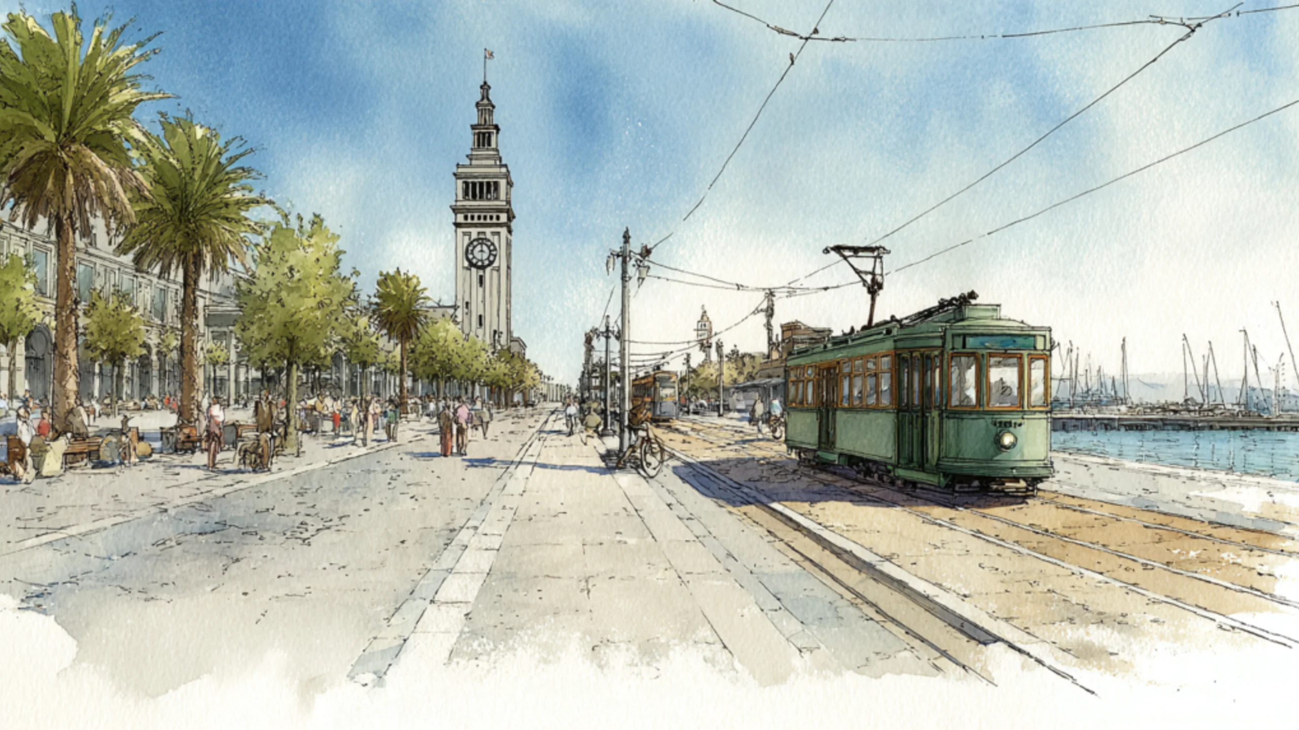
The double-decker concrete spur, built along the eastern waterfront in the late 1950s, had cut the city off from its own bay. From below, the Ferry Building looked less like a civic landmark than something trapped beneath a piece of unfinished infrastructure. Cars moved overhead. The city endured underneath.
The earthquake left the structure standing but crippled. The city faced a choice: repair it, replace it or remove it. Those who wanted it repaired argued for continued car access to Chinatown and Fisherman's Wharf. Mayor Art Agnos backed demolition, which began in a steady rain on 27 February 1991. In December that year he lost his re-election runoff to Frank Jordan, who had opposed the teardown. The traffic catastrophe that opponents had predicted did not arrive.
Today the waterfront has a boulevard, streetcars, walking routes and public space, and people can reach the water without passing beneath a motorway. The larger change was a discovery: San Francisco could live without the freeway.
That discovery unsettles a durable assumption in transport policy: that traffic is a fixed quantity of vehicles which must be accommodated somewhere, like water flowing through pipes. Close one pipe and the same volume must burst through another. Add a pipe and everything will flow more easily.
People have calendars, jobs, preferences, budgets, children, alternatives and a large capacity to change their plans. The useful question is which journeys will still be made by car, when, by whom and at what cost.
This is the story of induced demand when roads expand and traffic evaporation when they contract. It is also a story about what cities count, what they fail to count, and how a shortage of political imagination can masquerade as a law of physics.
The traffic that did not all disappear
In popular retellings, a huge freeway was removed and its traffic simply vanished. The record is more interesting, and a little less miraculous.
At its peak, the Embarcadero Freeway carried about 60,000 cars a day. The six-lane boulevard that replaced it carried about 26,000 in 2000, according to case studies by Norman Garrick and Jason Billings at the University of Connecticut. Those figures do not mean that 34,000 daily trips vanished from the regional economy.
Some drivers changed routes. In a later study of three removals, two in San Francisco and one in Milwaukee, Garrick and Nicholas Lownes found that the new boulevards carried between 35 and 70 percent of the former freeway volume. Across the three areas, the overall change in traffic on the surrounding streets ranged from a 17 percent fall to a 44 percent rise. Where the boulevard was well integrated into the street grid, as on the Embarcadero, traffic spread more evenly across the area. BART ridership rose by about 4 percent, a shift the authors were careful not to attribute to the removal alone.
The essential prediction still failed. Robert Cervero, Junhee Kang and Kevin Shively at UC Berkeley reviewed the San Francisco removals and found that much of the downtown traffic moved to other Bay Bridge ramps and to the grid south of Market Street. Better signal timing, restriping, one-way couplets and expanded transit absorbed much of the rest, and the city avoided the traffic nightmares that had been predicted. They also noted that congestion in San Francisco as a whole kept getting worse. The F-line heritage streetcars reached Fisherman's Wharf along the waterfront in March 2000.
The careful conclusion, then, is that the cars using a road are partly a product of the road's existence.
The road that creates its own customers
Traffic engineers once had a convenient way of thinking about congestion. Measure current demand, forecast population and economic growth, then add capacity to carry the resulting vehicles. Where the road is full, enlarge the road. The model appears sensible because it treats travel as a need that exists independently of the transport system.
But the cost of a journey shapes whether and how the journey is made. A driver pays for fuel, parking and tolls, and also in time, unreliability and discomfort. Economists call the combination generalized travel cost. Change that cost and people change their behavior.
Add a lane to a congested road and, for a while, driving may become faster. Some people leave earlier or later than before; others stop carpooling, abandon a train or bus journey, make an additional shopping trip, choose a more distant workplace, or move into housing that would previously have meant an intolerable commute. Businesses also adjust where they locate and how they distribute goods. Over time, land development and transport choices rearrange themselves around the new capacity.
In 2011, economists Gilles Duranton and Matthew Turner published a landmark study of US cities in the American Economic Review. They found that vehicle-kilometers traveled on interstate highways rose in proportion to highway lane-kilometers. The extra driving came from current residents driving more, from more commercial traffic and from people moving in. New lanes diverted little traffic from other kinds of road.
This is sometimes summarized as more roads produce more traffic. That is broadly correct in congested, demand-rich urban networks, but it should not be turned into a universal spell. A rural road with spare capacity does not necessarily fill the moment somebody paints another lane. The crucial conditions are latent demand, attractive destinations, alternative travel choices and enough time for behavior to change.
A wider road can still improve reliability or provide essential access. Induced demand means that a long-term congestion forecast is wrong if it assumes that today's drivers will remain the only drivers after driving becomes easier.
The new lane helps create the demand it was built to serve.
Traffic behaves like people
The phrase traffic evaporation describes ordinary human adaptation, observed at scale.
When road space is reduced, several things can happen at once. Some drivers take another street. Others change departure time. Some use public transport, walk or cycle. Some combine errands or work remotely. Some trips are made less often. In the longer term, households and businesses may change locations, although such adjustments are slower, costly and unequally available.
One person changing a departure time is unremarkable. Ten thousand people making a thousand different small changes can transform a traffic forecast.
Sally Cairns, Stephen Atkins and Phil Goodwin examined more than 70 cases of road space reallocated from general traffic in 11 countries, and gathered the views of more than 200 transport professionals. They found that predictions of traffic problems were often unnecessarily alarmist, and that, given the right local circumstances, overall traffic could fall significantly as people made a far wider range of responses than planners had assumed. They did not claim that every scheme succeeds or that every missing vehicle has become a transit passenger. The finding was modest and subversive at once: removed capacity need not reappear as equivalent congestion elsewhere.
There is an important asymmetry here. If people stop taking a low-value car trip, the traffic count falls and society has lost little. If a nurse cannot reach a night shift because no usable alternative exists, the traffic count also falls, and that is an accessibility failure. Cities must measure people's ability to reach work, care, education and one another, and ask whom each vehicle reduction burdens.
The pipe model therefore makes a moral mistake as well as a mathematical one. It counts moving vehicles as the objective, when they are one instrument among many for moving people.
Braess's paradox: the selfish shortcut that slows everybody
In 1968, the German mathematician Dietrich Braess described a road network in which adding a new connection made every driver's journey slower. Each driver chose the route that looked quickest. Once the shortcut was available, too many chose it, changing congestion across the network. What was rational for each individual was worse for everyone together.
This is Braess's paradox: a possible outcome of selfish route choice in a congested network, for a given level of demand. It is not a universal law that every highway removal improves traffic, and nobody has shown it to be the explanation for what happened on the Embarcadero. Whether the paradox appears depends on network structure, traffic volumes and how travel times respond to congestion. One study showed that, in Braess's network, the paradox occurs only when total demand falls within an intermediate range.
The lesson reaches beyond traffic: more options for individuals can produce a worse collective outcome. The efficient network and the route that seems fastest to each driver are different things.
San Francisco's evidence suggests a related, less exotic mechanism: traffic concentrated on the elevated road could be redistributed across an existing network with some unused capacity. Removing a dominant link left the city's capacity to move people largely intact. In some cases, the street grid proved more resilient than the concrete funnel suspended above it.
A street grid can also gridlock, and loading residential streets with dangerous through-traffic is no achievement. Network performance must be measured as a system, and cannot be inferred from the number of lanes in one impressive structure.
Seoul: when a highway became a stream
San Francisco's demolition followed an earthquake. Seoul's was a deliberate act of urban reinvention.
By the beginning of this century, the Cheonggyecheon corridor through central Seoul was a ten-lane road with a four-lane elevated highway above it, laid over a stream that had been covered in concrete between the late 1950s and the 1970s. Together they carried more than 170,000 vehicles a day. The figure is often given as the elevated highway's own traffic, but it describes the corridor.
Work began in July 2003. The city demolished the elevated road and rebuilt 5.84 kilometers of stream-centered public space, which opened on 1 October 2005. The argument against it was familiar: the road was too busy to remove, and a city could not subtract that much capacity from its center.
Seoul changed its transport system alongside the decision. The city completed a reform of its bus network in July 2004, more than a year before the stream opened: routes were reorganized and buses got dedicated median lanes on the main roads. Kee Yeon Hwang, president of the Korea Transport Institute, said in 2011 that the restoration triggered the bus reform, and that the city's existing subway lines helped absorb the change. The removed road came with new choices, and the transformation took governance.
A 2012 study by Jin Hyuk Chung, Kee Yeon Hwang and Yun Kyung Bae followed travel in the corridor, where the surface street went from four lanes to two in each direction. The sequence was more complicated than the usual success story. Immediately after construction began, travel speeds fell and traffic volume rose. At the same time, subway use increased and road trips decreased as travelers adapted. The apocalyptic scenario did not become the city's permanent condition, and the transition was not frictionless.
The outcome was larger than traffic. The new Cheonggyecheon gave central Seoul a continuous walking landscape, water, shade, bridges and places simply to be. The Landscape Architecture Foundation's case study reports temperatures along the stream 3.3–5.9°C cooler than on a parallel road four to seven blocks away. That is a local, comparative microclimate measurement, and it does not show that the whole city became several degrees cooler. Between 2003 and the end of 2008, the number of plant species recorded along the stream rose from 62 to 308, fish species from 4 to 25 and bird species from 6 to 36. Over the same years bus ridership in Seoul rose 15.1 percent and subway ridership 3.3 percent, increases the foundation says the project contributed to.
The costs were real. The stream is largely artificial: outside the summer rains, its flow is water drawn from the Han River and from groundwater seeping into subway stations, treated and pumped in. Construction disrupted merchants and street vendors, some of whom had to move. Rising land values brought benefits but also pressure on less secure occupants. A polished riverside is not automatically a socially just one.
Even so, Seoul inverted a long-standing order of priorities. The road had been treated as essential infrastructure and the stream as expendable landscape. The city reversed the judgment, and in doing so it treated public space, cooling, walking, ecology and social life as infrastructure too.
Oslo halves a tunnel
The same behavior has been observed in an ordinary Nordic road network, without an earthquake or a river restoration.
In February 2016, rehabilitation work cut the Bryn tunnel on Oslo's Ring 3 from four lanes to two, one in each direction, until April 2017. Before the works it carried about 66,000 vehicles a day, which made it one of Norway's busiest road links. The obvious expectation was that the missing capacity would reappear as severe congestion somewhere else.
Researchers at Transportøkonomisk institutt (TØI), the Norwegian Institute of Transport Economics, followed the experiment. In the first report, the morning peak through the tunnel fell by 24–41 percent at different counting points. The final report put the fall at 23–34 percent in the peak hours and 20–23 percent across the day. Two alternative main roads carried more traffic; local roads changed little; and total traffic in the system appears to have fallen. Travelers chose other routes, other modes and other departure times, and worked from home more often.
Delays grew in the tunnel and on the roads around it, and journeys became less predictable. The network did not collapse. TØI's conclusion was that halving the capacity of one of Norway's busiest road links caused inconvenience for every kind of road user, and no crisis.
When the tunnel reopened at full capacity, traffic and speeds rose again, though traffic did not return to its earlier level.
Oslo matters because it cannot be explained by a spectacular waterfront or by Seoul's subway. Travelers in an ordinary network adjusted when the perceived costs of driving changed. It also offers a warning: once capacity returned, some of the car traffic returned with it. A temporary restriction can reveal flexibility; durable change usually needs durable alternatives and land-use policies.
Three waterfronts, one error
Portland tore up Harbor Drive along the Willamette in 1974 and began building a waterfront park on the land, renamed Governor Tom McCall Waterfront Park in 1984. The city's own park history recalls that the 1903 Olmsted Report had called for a greenway along the riverbanks to preserve them, an ambition deferred through decades of road building.
San Francisco reclaimed a bay front. Seoul reclaimed a stream. Portland reclaimed a riverbank. Each had first given a valuable urban edge to the movement of private vehicles. Each then discovered that the space could carry other kinds of value which a traffic model had little reason to recognize.
The pattern echoes the 1930 plan that the Olmsted Brothers and Harland Bartholomew & Associates drew up for Los Angeles, Parks, Playgrounds and Beaches for the Los Angeles Region. It proposed a regional system of parks, parkways and beaches; the committee that commissioned it never adopted it, and the region organized much of its movement around freeways instead. What cities decline to reserve for public life becomes much harder to recover once roads, land speculation and private development have settled upon it.
There is a pattern here, and it is no magical recipe: good road-removal projects coordinate land use, transit, surface-street management, walking, cycling and public-space design. They are urban projects that happen to remove roads, which is very different from an engineering project whose only achievement is less asphalt.
The political power of the congestion forecast
Why, then, do predictions of traffic catastrophe survive so many contrary examples?
Partly because a congested road is visible. Its queues can be photographed, counted and broadcast on the evening news. The lost playground, the absent riverside path, the person who cannot afford a car, the child who cannot cross an arterial road, the elderly pedestrian waiting through three signal cycles: these are dispersed costs. They rarely appear as one dramatic queue.
Partly because conventional traffic models have often held travel demand more fixed than it is, especially for short-term project appraisal. They calculate where existing drivers might divert much more readily than they predict how thousands of people will change routines, destinations and eventually homes. Better models exist, but they require behavioral assumptions that can be contested and tested.
And partly because the political risk is asymmetrical. A mayor who removes a lane can be blamed for the first delayed delivery truck. A mayor who preserves a damaging road is rarely blamed, on the same afternoon, for another year without a park. The status quo presents its injuries as background conditions. Reform must defend itself against the weather.
That asymmetry creates an urban conservatism disguised as technical caution. Every road is treated as indispensable because it is currently used. But a road's present use is partly the consequence of the choices that produced it. A count of 100,000 vehicles a day describes how a corridor is used under today's prices, routes and alternatives, and gives no warrant for keeping those 100,000 vehicles there forever.
The distinction is between describing an equilibrium and justifying it.
The uncomfortable limits of evaporation
Reallocating road space imposes real costs on some people, and the case for it has to say so.
Some people must drive. Care workers on night shifts, tradespeople with equipment, disabled travelers, emergency services, deliveries and people living far from frequent transit do not all have the same range of choices. Travel flexibility is socially distributed. An office professional can often move a meeting online; a hospital cleaner cannot clean a ward by video call.
Removing a road does not guarantee cleaner air on every adjacent street either. Traffic can shift into residential areas. Congestion and emissions can worsen locally even when total car use falls. A restored stream can raise nearby property values and displace the people who endured the old highway. A boulevard can remain hostile if it is designed as a smaller highway with decorative trees.
Success therefore requires more than a before-and-after photograph. It requires honest measurements over time: changes in travel speed and reliability across the whole network; total car trips and vehicle-kilometers; transit performance and occupancy; access to jobs and essential services; freight and emergency access; air pollution and noise on adjoining streets; crashes; rents and displacement; and the quality of the space returned to public use.
It also requires a comparison with a credible counterfactual. Traffic might have fallen anyway because of recession, fuel prices, changing work patterns or other investments. A city that credits a road closure with every good change that followed has merely replaced old traffic dogma with a greener variety.
Some roads clearly have to stay. The policy question is which roads provide enough social value to justify their costs, and where the same scarce urban space would produce more value in another use.
How to plan for less road and more city
First, model people as well as vehicles. Forecast changes in mode, time, route, destination, trip frequency and eventually location. Test several behavioral responses instead of assuming every existing car journey must be reassigned unchanged.
Second, make credible alternatives arrive early. Increase transit frequency and reliability, give buses priority, secure safe walking and cycling routes, and protect essential access before removing capacity. Seoul finished reforming its buses more than a year before the stream opened.
Third, protect the surrounding streets. Use turn restrictions, signal coordination, traffic calming, delivery management and residential filtering where needed. A road removal has failed its neighbors if it pours through-traffic past their front doors.
Fourth, define what the reclaimed land is for. Parks, housing, tram tracks, flood protection, trees, public markets, cycle routes and generous sidewalks should be treated as measurable project benefits. The value of a new waterfront cannot be reduced to the travel time of the cars no longer passing over it.
Fifth, take equity seriously from the beginning. Maintain access for people with constrained mobility or working hours, and couple environmental improvements with affordable housing and protection from displacement. Otherwise a city may replace traffic injustice with property injustice.
Finally, collect evidence before and after. Publish the assumptions, traffic counts, journey times and distributional impacts. Measure again after one month, one year and five years. If a feared disruption appears, fix it. If the network adapts, learn from it. Planning should have the courage to change its mind in the presence of evidence.
What exactly is a street for?
The Embarcadero's deepest lesson is that the city had mistaken one use of its waterfront for the waterfront's purpose.
Road capacity is valuable because it provides access. But access and driving are different things, and so are driving and prosperity. Sometimes a roadway genuinely connects a region. Sometimes it devours a riverbank, divides a neighborhood and induces more of the traffic it is meant to cure. Often it does a little of both. Adult politics begins where the simple slogans end.
When a new road is proposed, the conventional question is how much traffic it will carry. When an old road is threatened, the question becomes where its traffic will go. Both questions quietly assume the car to be the city's primary citizen.
A more civilized city would begin elsewhere: who needs to reach what, how reliably, at what human and environmental cost, and what else could this land become?
San Francisco's waterfront was hidden by concrete. Seoul's stream was buried beneath it. Oslo's tunnel showed how quickly ordinary travelers could reorganize their days. In none of them did the traffic simply vanish, and each exposed the same error: travel demand is shaped by the city we build.
For decades cities widened roads to free urban life from congestion. Sometimes the first act of freeing it is to take the road away.
The city had been helping to create its traffic all along.
Selected evidence and further reading
- Norman Garrick and Jason Billings, Case Studies of the Access and Mobility Impact of Freeway Removal, New England University Transportation Center (2013): Embarcadero Freeway and boulevard volumes, with comparison cases in Boston, Paris, Seoul and elsewhere.
- Norman Garrick and Nicholas Lownes, Case Studies of Freeway Removal, final report UCNR21-9, New England University Transportation Center (2013), and Jason Billings, Norman W. Garrick and Nicholas E. Lownes, Changes in travel patterns due to freeway teardown for three North American case studies, Urban Design International 18(2) (2013): boulevard share of former freeway volume, surrounding-street changes and BART ridership.
- Robert Cervero, Junhee Kang and Kevin Shively, From Elevated Freeways to Surface Boulevards: Neighborhood, Traffic, and Housing Price Impacts in San Francisco, University of California Transportation Center working paper (2007).
- Federal Highway Administration, Highway History: February 27: the start of the Embarcadero demolition in 1991. SPUR, When the freeways came down (2010).
- San Francisco Municipal Transportation Agency, Celebrate the 30th Anniversary of the F Market Line at Muni Heritage Weekend (2025): the Fisherman's Wharf extension, opened 4 March 2000.
- Gilles Duranton and Matthew A. Turner, The Fundamental Law of Road Congestion: Evidence from US Cities, American Economic Review 101(6) (2011).
- Sally Cairns, Stephen Atkins and Phil Goodwin, Disappearing traffic? The story so far, Proceedings of the Institution of Civil Engineers: Municipal Engineer 151(1) (2002).
- Dietrich Braess, Über ein Paradoxon aus der Verkehrsplanung, Unternehmensforschung 12 (1968); English translation by Braess, Anna Nagurney and Tina Wakolbinger, On a Paradox of Traffic Planning, Transportation Science 39(4) (2005).
- Eric I. Pas and Shari L. Principio, Braess' paradox: Some new insights, Transportation Research Part B 31(3) (1997).
- Global Designing Cities Initiative, Case study: Cheonggyecheon, Seoul, Global Street Design Guide.
- Landscape Architecture Foundation, Cheonggyecheon Stream Restoration Project: cooling, biodiversity, ridership and water supply.
- Jin Hyuk Chung, Kee Yeon Hwang and Yun Kyung Bae, The loss of road capacity and self-compliance: Lessons from the Cheonggyecheon stream restoration, Transport Policy 21 (2012), also on the Yonsei University repository.
- TransLink Buzzer, On removing freeways and reforming buses: an interview with Dr. Kee Yeon Hwang (2011).
- Transportøkonomisk institutt, Effects and consequences of capacity reduction in the Bryn tunnel per 2016, TØI report 1566/2017, and final report, TØI report 1754/2020.
- City of Portland, Governor Tom McCall Waterfront Park: Harbor Drive and the 1903 Olmsted Report.
- Greg Hise and William Deverell, Eden by Design: The 1930 Olmsted-Bartholomew Plan for the Los Angeles Region, University of California Press (2000).
Continue Reading
America's Borrowed Harvest: The Towns Holding the Groundwater Debt
For seventy years the High Plains and California's Central Valley have farmed on water that rain does not replace. The fields still look green. The bill is arriving in the towns: a levee that keeps sinking in Corcoran, dry taps in East Porterville, a wastewater plan in Dodge City that farmers are fighting in court.
The View from Below: How London Mistook Skyscrapers for Density
London spent twenty years building upward in the name of the compact city. From the pavements of Shoreditch the arithmetic looks different: the tower privatises the panorama and socialises the silhouette.
The Los Angeles That Almost Learned to Walk
In 1930, a regional parks plan and an electric rail network could have made Los Angeles a polycentric, walkable, tram-linked metropolis. The city commissioned the plan, then put it in a drawer. This is the anatomy of a choice, not a fate.